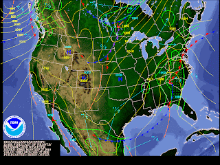
Once these waves arrive closer and pass through our CWA, there looks to be some energy associated as well as some lifting air or overrunning (isentropic lift is the physical lifting of air in which it can be characterized by widespread stratiform clouds, precipitation, and may also include elevated convection in the form of embedded thunderstorms) (NWS), especially towards the Northwestern parts of the area where they could see some heavy rain and a thunderstorm can not be ruled out.
 |
| 1200Z Mon 12/9 Courtesy from HPC/NCEP |
The Storm Prediction Center (SPC) has placed our area under a slight risk for severe weather, especially towards this evening through Tuesday, due to the instability in the atmosphere and the shearing gusting winds moving in this evening, becoming stronger Tuesday, as well as if there is enough added moisture and warmer temps by this evening. Winds are forecasted to become rather impressive this evening, especially aloft, but near the surface, near 10-15 mph Monday evening, becoming 15-20 mph with gusts up to 30 mph Tuesday. With the added wind gusting Tuesday, the chance for shear (variation in wind speed and/or direction over a short distance within the atmosphere. Shear usually refers to the vertical wind shear: change in wind with height) (NWS) increases as does the chance for convective or severe weather.
 |
| 1200Z Tues 28/9 Courtesy from HPC/NCEP |
For the most part, this week will consist of unsettled weather. Remember, even though it may be considered to be the Fall season, the weather goes through a few weeks of transition, if you will, where the weather patterns can usually be rather erratic before it finally settles into the season.
Considering this, temperatures will be all over the board ranging from blistering heat last week, humid and flirting with the 80s Tuesday, to middle to lower 70s towards the end of the week.
**Some of the weather models are leaning towards our first frost Sunday!** In the Suburbs, nighttime lows Saturday P.M.- Sunday A.M could be in the mid 40s, and in the higher elevations, temperatures could be as low as the upper 30s! Typically, the first frost occurs over the Northern states around the Autumnal Equinox, however, with our erratic transition, it has been delayed about a week or so.
No comments:
Post a Comment