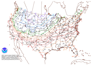
A pocket of very cold arctic air; I'm talking about the single digits here, is stuck up in the northern plains (Wisconsin, the Dakotas, Minnesota), whom I might add, will get walloped with s hefty snow storm (a foot plus of snow) late this weekend through early week. Temperature currently in that region of the States are ranging from the 20s as daytime highs falling to the single digits, even flirting with 0 (zero) degrees F in the evening. Our Tri-State (thankfully) will not feel temperatures quite as cold this time around however, we still do have a good shot this Winter.
 |
| Temperature Anomalies Courtesy of HPC/NCEP |
 |
| Very warm temps over our area Tues! Courtesy of HPC/NCEP |
As for now, I will play it safe and say that we may see some showers Tuesday. Otherwise cloudy skies and very warm temperatures (life flirting with the 70s warm!)
The dreaded holiday commute begins Wednesday. For those of you who are rather wise, the commute will begin Tuesday. The rain will move out by Wednesday and should be smooth sailing, well, as far as the weather goes. Traffic is another issue.
Since it is a long way out forecast models are still trying to come in agreement with each other. At this time, a middle level low of moderate intensity is forecasted to move from the Northern Plains to the Great Lake region. Models are showing this to support a surface low that will develop and move from the Plains to the Great Lakes towards Thursday, Thanksgiving. Following this low are some very cold, below normal temperatures that will track into our area Friday. This is nothing like sitting in line early Black Friday morning in freezing temperatures! This unseasonable weather pattern is indicative of the La Nina Oscillation in which
there is a variable Pacific Jet Stream streaming the Polar Jet through the Upper Plains down through New England. with more stormy weather and increased cold weather outbreaks; i.e. cooler and unseasonable weather.
Now, I don't know about you, but I am ready for Winter. I am really not looking forward to feeling the upper 60s, although it is usually welcomed, not now!
Stay tuned for more holiday updates!
~ V.S.
No comments:
Post a Comment