Sunday, November 28, 2010

Starting the Snow Machine!

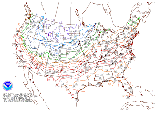
Although it is still the Fall season, aside from the little refreshing warmth early this week, it has been quite cold! Saturday was especially bitterly cold! However, the cold temperatures we (in the Tri-State) felt the past few days is not even comparable to single digits felt in the Northern Plains.
This post was inspired by a gorgeous friend who was interested in the idea of lake-effect snow. Right around this time of year through January, lake-effect snow is a pretty hot topic for the Great Lakes and surrounding areas; so why not write about it!
The general notion of the weather that occurs at a given moment or time is due to fronts i.e. cold, warm, stationary and so on. Cold fronts are followed by cooler air (CAA: cold air advection or movement of air) then what was previous in place prior to the frontal passage and so on. However, what the general public do not take into consideration that the weather and weather forecasts are largely influenced by air masses. An air mass is an extremely large body (area) of air which the properties of temperature and moisture content (humidity) are similar in any horizontal direction at any altitude. This area that an air mass encompasses is not just a few kilometers. It is more like a few thousand kilometers. Not only is temperature an important component. The actual source region of the air mass is a very important characteristic. These regions are where the air masses originate. In order for a such a huge mass of air to develop and to form characteristics from the source region, the air mass must remain stagnant over the region for a long(ish) period of time and thus will acquire the properties from the surface below.
There is one more part to the puzzle before I get to the snow machine. When it comes to air masses, there is a classification. Like mentioned before, air masses are classified according to their temperatures and humidities. There are warm and cold air masses, we well as there are moist and dry air masses. The image below refers the the kinds of air masses, their source regions, and the characteristics.
North American Air Masses
Now that we have a little background information on air masses, the idea of lake-effect snow can be explained. With air masses and source regions in mind, when a cold, dry air mass moves over a relatively warm body of water (the Great Lakes), heavy snow showers can form, also known as lake-effect snow! From November through January when the weather in the Mid-west is more of less dominated by clear and cold cP (continental polar) air, locations on the eastern shores of the Great Lakes often experience snow, sometimes heavy in nature. These snow showers that form on the downwind side of one the the lakes is known as lake-effect snow. The snow could fall as showers to even heavy snow squalls. Depending on the wind flow direction, part of a city/town area could experience just simply clouds while the other side of town could have a few inches of snow on the ground! The image below depicts the formation of lake-effect snow. 
Lake-Effect Snow Courtesy of MetEd
Between November and January, cold air moves over the Great Lakes when they are still relatively warm and not quite so frozen. Some studies have actually noted that it is the contrast in temperatures between the water and air that is the potential for snow showers. This difference can be as great as 45 degrees F! Referring to above, when cold air moves over the warmer water, the air mass is quickly warmed from below making the air more buoyant and less stable. Over the water, the water the vapor condenses into fog steam, warming as it rises and form cumuliform clouds that continue to grow and before more unstable. In time, these clouds will produce snow showers. Right on the eastern shores of the Great Lakes is the most snow. However, here in Jersey we have seen a few lake-effect snow flurries, but will never receive much accumulation. Once the air and clouds reach the eastern shores, additional lifting of air is provided by low laying hills. The terrain and the convergence of air slows down the amount of snow accumulation and the snow eventually tapers off leaving trace amounts or low laying cumulus clouds drifting over head. Over the Winter season, as the lakes begin to freeze, lake-effect snow showers become more numerous because there is less of a temperature contrast between the surface and the air. Just a note: the longer the distance over which the air mass travels, the greater the amount of warmth and moisture is taken from the waters, and the greater the potential for heavy snow. This lake-effect snow can bury a city in a matter of few days! In just a few days in December 2001, Buffalo, NY received just about 7 feet of snow. Compare that to Montague, NY in January 1997 that received over 7 feet of snow in less than 48 hours!
Let the snow factory open shop!

~ V.S. 

Wednesday, November 24, 2010

Happy Turkey Day!

Even though the past few days for us in the Tri-State was rather refreshing welcoming the mild temperatures. Some things just need to come to an end. In our case, we need to start having some kind of balance in the weather. The more the temperatures become mild and stay like that for days on end, the whole ecosystem will pretty much more or less get confused as to what season we are actually in. If you remember the Winter a year ago, we had a few days of unseasonably warm temperatures and the ground and plants began to 'defrost' from the cold. Trees and plant began to bud. Hibernation was disturbed. A week later another cold snap moved through damaging and killing all the budding plants that thought it was time to peek out.
Cycles, seasonal cycles. It is what makes the world go around. Mother Nature needs balance, we need balance to survive and exist.

The lovely high pressure from Canada that brought us sunny skies Wednesday will slide off towards the East through the evening as a rather strong cold front (with very cold temperatures following) will move through gracing us with lovely stormy weather for the holiday. Much like what I had mentioned the other day, the weather we will experience throughout the area will all be based on timing and placement (much like all weather events).  For the most part, the main event will not happen until early afternoon Thursday (for Western PA,NJ/NY). There is still time for smooth holiday travels before the weather takes a turn for the worse. Increasing clouds through the early morning hours will change to rain by afternoon becoming more steady as the day progresses.
The storm will continue to strengthen through the early morning hours Thursday before it reaches our area. A warm front will be placed to out southwest will become stronger and energized as it lifts and moves towards the northeast. There will be pretty strong warm air advection (waa) at the mid-levels which will add the the increase of clouds.
Yes, it is going to precipitate. The models have been predicting that for the past week. The main issue at hand, in income overrunning precipitation band  (a relatively warm air mass of greater density at the surface which is associated with embedded thunderstorms. Typically, overrunning occurs when warm air is riding over a layer of colder air) that which is positioned northeast of the warm front. However, models are hinting that the front will hit a wall of drier air, therefore not allowing a great deal of precipitation.
The fun part for this forecast come into play when trying to figure out where the wintry mix will fall. Yes, I did mention a lovely wintry mix. This is where the timing comes into play. The wind field will increase bringing in a very cold air from the Ohio Valley. A very cold airmass mixed with drier air will make it rather conducive for evaporative cooling. Pretty much all the model have hinted at evaporative cooling, which at this time, will knock down temperatures a few degrees through the whole area and could allow a wintry mix to fall to the surface. Little to no snow accumulation will occur Thursday.
No more mumble jumble...I'm getting myself too excited!
Ok. out of all of what I said: Increasing clouds through the morning Thursday. Rain is to be expected first followed by a wintry mix once we receive the colder air from the West. A Winter Weather Advisory has been posted for the potential for some nasty weather and for people to be advised on the holiday.
Cold temperatures will move in Thursday through Friday. Those of you waiting in line for Black Friday sales; bundle up! Expect temperatures early Friday to be in the lower 30s increasing through the day. More showers are possible and quite likely through Friday. At least the rest of the weekend will be nice. Breezy Saturday and it will feel quite cold considering high temperatures will only be in the middle 40s! Saturday evening....the coldest temperatures of the season! Expected lows will fall to the 20s!!!!

Safe travels, stay warm. Eat, drink, and be merry!

~ V.S.


Sunday, November 21, 2010

Milder Air Moves In!

Milder air will make it way in Sunday evening and will stick around for much of the week. Unseasonable temperatures will be flirting with the 70s by Tuesday. Model ensembles are still not in agreement as far as the weather for the holiday week. As of yesterday evening, I had mentioned that there is a chance of showers in the late week; raining (no pun intended here :-p ) on your Thanksgiving Day parade. But hey, a turkey day touch football game in the rain could be SOO much fun!
Now, depending on who fast or slow this middle level low develops over the Great Lake area, would end up being a difference of clouds or rain or even a mix bag of precipitation treats for Thursday. The later the precip. move in, the greater the chance that of a freezing rain mix would fall over the Northern areas and higher elevations. The models are also suggesting that a triple point could move through the Southern parts of the area. A triple point is the intersection point between two boundaries like a cold front and a dry line for example. One of the main concerns here is the convection development i.e. thunderstorms. The triple point can also be said to be a gust front or a supercell (another one of my favorites!) where the warm moist inflow, the rain-cooled outflow from the forward flank downdraft, and the rear flank downdraft all intersect which is quite a favorable location for redevelopment of the storm or tornado formation (NWS). Refer to the image below for illustration of a triple point.
Surface Map depicts a triple point. Courtesy of Chasing Storms.
It has been noted by the models that a triple point could move through the area at some point Thursday which could trigger off a few storms especially to the southern parts of the areas mostly because of the warmer temperatures. However, with all said, this is just a POTENTIAL forecast of what COULD happen. All could change in the next model run, and will continue to change through the course of early week. What is certain for sure is a shot of colder air that will bring temperatures much below normal for the end of the week and weekend.

I will keep you updated on the holiday weather as changes are made. For near term expect warmer temperatures and mostly cloudy skies with scattered showers through much of Tuesday. 

~ V.S.

Saturday, November 20, 2010

Getting Ready for the Holiday!

Some of the coldest weather of the season is yet to come!
A pocket of very cold arctic air; I'm talking about the single digits here, is stuck up in the northern plains (Wisconsin, the Dakotas, Minnesota), whom I might add, will get walloped with s hefty snow storm (a foot plus of snow) late this weekend through early week. Temperature currently in that region of the States are ranging from the 20s as daytime highs falling to the single digits, even flirting with 0 (zero) degrees F in the evening. Our Tri-State (thankfully) will not feel temperatures quite as cold this time around however, we still do have a good shot this Winter. 
Temperature Anomalies Courtesy of HPC/NCEP
For the rest of the weekend. High pressure will still play strong for much of Sunday,sinking South later Sunday evening. A cold front will stall out south of the area Sunday as a High pressure area pushes south from the North giving us another rather pleasant day of sunshine and seasonal(ish) temperatures we have had as of late. Clouds will be on the rise as is a risk of showers late Sunday due to the cold front (that was positioned in the South) lifts through our area as a warm front Sunday into Monday...This is when we will get a touch of the milder temperatures. 
Very warm temps over our area Tues! Courtesy of HPC/NCEP
With a southerly-southwesterly flow of air, temperatures will be pretty significantly warmer then Saturday and Sunday. We will be going from the 40s Sunday up to the 60s Monday! Clouds and showers will encompass the weather Monday through Tuesday. But the talk of the town will be the very mild temperatures! As of the latest models, The cold front from the west is forecasted to move in through Tuesday. As of now (again this can change), the front is expected to move through later Tuesday. With that said, the models are showing the the front could loose some of its moisture so not much rain could fall over our immediate area at that time as compared to the Western areas Tuesday. However, there could be a change in the forecast, and the front could end up moving faster or slower which puts us in that 'buffer zone' where we could actually get some heavy rain and storms or not so much.
As for now, I will play it safe and say that we may see some showers Tuesday. Otherwise cloudy skies and very warm temperatures (life flirting with the 70s warm!)


The dreaded holiday commute begins Wednesday. For those of you who are rather wise, the commute will begin Tuesday. The rain will move out by Wednesday and should be smooth sailing, well, as far as the weather goes. Traffic is another issue. 
Since it is a long way out forecast models are still trying to come in agreement with each other. At this time, a middle level low of moderate intensity is forecasted to move from the Northern Plains to the Great Lake region. Models are showing this to support a surface low that will develop and move from the Plains to the Great Lakes towards Thursday, Thanksgiving. Following this low are some very cold, below normal temperatures that will track into our area Friday. This is nothing like sitting in line early Black Friday morning in freezing temperatures! This unseasonable weather pattern is indicative of the La Nina Oscillation in which 
there is a variable Pacific Jet Stream streaming the Polar Jet through the Upper Plains down through New England. with more stormy weather and increased cold weather outbreaks; i.e. cooler and unseasonable weather.


Now, I don't know about you, but I am ready for Winter. I am really not looking forward to feeling the upper 60s, although it is usually welcomed, not now!


Stay tuned for more holiday updates!


~ V.S.

Wednesday, November 17, 2010

Taste of the Straight Line

Not only did I have to wake up at an ungodly hour this morning to prepare for my work day, I was awoken even earlier (at around 3 a.m.ish if you were wondering) to the marvelous sight outside my window! Most people would just roll over in bed and not bother with the sights and sounds of the weather. I on the other hand jump out of bed so fast and so awake, much like a kid running to see what goodies are under the tree Christmas morning. I admit, this was in part due to the fact that I was completely aware of what the weather last night (early this morning) had in store for us. I suppose I never really actually sleep well the night of or before a weather event just because I am anticipating what is to come. Yes, I already know. I am a freak.
The winds were howling and gusting up to 40 mph plus. According to the NWS, there was a recorded wind gust of 54.0 mph at 3:42 a.m. this morning at Trenton-Mercer Airport in Ewing, NJ that not only tore off parts of the roof on a hanger but also flipped and toppled planes on the tar-mat! Leaves were every where. Nearly none were left on the trees but a few. Some residents of Mercer County and other just of the Delaware River lost power. My business lost power and needless to say, made for such a lovely morning (but not in a good way)!
Straight-line wind derecheo associated with a curved cold front was the cause of all the destruction today.
Derecheo (derecho is Spanish meaning: straight). Derechos are associated with a band of thunderstorms and showers that are usually 'curved' in shape. However, the general criteria for a derecho is that the winds during the thunderstorm would have to be sustained at 58mph not gusting. In the case of last night, an intense (curved) cold front was moving across the area. The curvature  of the front bowed out storms and caused such strong winds. If you can remember a time when watching a weather report during a severe storm with the potential for tornadic activity, the meteorologists often mention watching out for a 'bow echo' which is a return on the RADAR in a mesoscale convective system (MCS's; which fyi is my favorite type of weather) in the formation of an archer's bow that produce severe weather and damage.
Formation of a bow echo.
The image below is shows the RADAR at 8:58:13 UTC, which is approximately 4:00 a.m. EDT. This is when the front passed through. Much of everyone was asleep when havoc was reeking just outside. Severe weather warnings were posted all throughout during this time. The purple line (that I drew) shows the curvature or bowing, of the front that caused such strong winds. 
NEXRAD RADAR. Courtesy of NCAR.
Winds were howling throughout the day following the frontal passage (the fropa); which by the the way looked absolutely gorgeous this morning towards sunrise. The calm after the storm will bring lovely weather once again. High pressure will dominate our weather once again. Sunny skies and seasonal temperatures will be the weather through the weekend. High temperatures will range from the lower to middle 50s falling to the middle to lower 30s with generally clear skies in the evening. Bellissimo!
Easter GOES Infrared Image. Courtesy of NOAA/NWS/NCEP
The image above is an infrared image showing the troughs (sinking air) and ridges (rising air); the battle between the lows (areas of clouds) and the highs (the clearer areas). Enjoy the Fall while it lasts, or whatever is left as far as the colors of the leaves on the trees. I am sure this past storm has swept Fall right out the door this morning; at least in parts of Jersey. Look on the bright side: the weekend is upon us with pleasant weather, making the storm clean-up at least a bit better ehh?

~ V.S.


Thursday, November 11, 2010

Will Update Soon...

Hello All,
This week is crunch time my friends! I have been slacking on my weather posts as of late. my apologies. I will be back (back) on track as of this Saturday. See, I am taking the Praxis (II) exam this weekend and studying has literally been taking up all of my spare time, or what other free time I have outside of work.
I will leave you with the following:


1.) I know some of my fellow (tv) mets. have already made their winter weather forecasts. I will say that I have been looking into this and I am currently working out my forecast. Plus, honestly, it is just too early to forecast for a season that is still a little way out.


2.) Until my next post, I can promise you that the weather in the Tri-State will be quite lovely. That means this will be perfect weather to take advantage of! Sunny skies and temps flirting with the 60s falling to the 40s in the evening.


Enjoy the gorgeous weather and wish me luck!


~V.S.

Monday, November 8, 2010

Weird Weather

Considering that I am "THE weather woman" at the local Starbucks, there is quite a high expectation when it comes to knowing everything about the weather including details on the daily forecast. Today my friends, I am admitting to falling short on being knowledgeable about the cool weather the North East has experienced today (Monday). My only excuse is that for the past week despite the lovely curve ball life has thrown me, my head has been too far up my you know what, to even muster the energy to study and discuss the current weather. One of my lovely customers this morning came into the store looking for me to tell me all about the weather that we were having and wanted to know why, when he unfortunately found out that one, I was not in for my shift yet, and two, I didn't know what was going on besides it being a bit breezy this morning.
Now that I have done my research, let us talk weather!

So, what happened today in the North East, was a pretty rare event. Something to be quite excited about. After realizing what was going on, I wished I had known about this yesterday!
As of this morning, there was a deepening low pressure system off the Cape Cod coast and was moving Southwest! Storms typically do not move in the Southwestward direction. This storm was like a reverse Nor'easter... very cool. Nor'easters are systems that generally form off the East coast and move North and East. This storm was back tracking a Nor'easter. Considering how dry the air was in central Jersey that is, the dynamics from this particular storm did not hold has much 'umpf' as a typical Nor'easter.
For portions of New York, New Jersey, and Pennsylvania, a Wind Advisory was posted for the potential for winds of 20-30 mph, higher winds near the coast, throughout the day. The gradient (the rate of change with respect to distance of a variable quantity, as temperature or pressure, in direction of max. change. NWS.) was forecasted to tighten; meaning there was a strengthening in the system and potential for high winds, as the system deepened (decrease in central pressure of a surface low systems; an intensifying storm) on its Southwest trek.
Towards the afternoon, when the low reached it intensity, the wind advisory that had been earlier posted was canceled as upper air sounding became less adiabatic (changes in temperature caused by the expansion; cooling, or compression, warming, of an area of air as it rises or descends in the atmosphere, with no exchange of heat with the surrounding air (NWS)). As the low began to retrograde (the movement in the opposite direction) at its peek and slowly began to stabilize, as drier air crept its way wrapping around the system. The dry air was was kept the bulk of the precipitation from falling. Otherwise, categorical precipitation could have fallen. Some areas, mostly in the higher elevations, but was also observed locally, experienced sleet. The drier air that was over our air evaporated (evaporation is a cooling process) cooled our air mass which made it possible for sleet to fall.
Now, 'sleet' is along with other types of precipitation is a pretty neat phenomena. I will save that lesson for another time. Sleet is defined as pellets of ice composed of frozen raindrops or refrozen partially melted snowflakes. Do not be confused with hail, because sleet in typically smaller than hail; usually hurts and stings a lot more when hit by it, unless of course you're hit by a baseball size hail ball that was falling at 75 mph plus!
Depiction of Sleet Formation. Courtesy of NWS
The higher elevations had sleet and snow flurries along with portions of Massachusetts and Connecticut. Tis' the time for snow to fall! Scattered showers and rain fell in central New Jersey. I might add, it was quite cool to see today a cutoff line in the sky to the West in Pennsylvania where you could see a separation between our gloomy skies rain skies and the sun and clouds.
Red arrows show counterclockwise wise circulation, white arrow shows system track .Courtesy of NOAA/NWS
NOAA GOES East Infrared Image. Courtesy of NOAA

High pressure is forecasted to move in Wednesday setting up shop for most of the week. With the exception of early Wednesday with few clouds, mostly sunny skies is what the hi-light is going to be. Temperatures will get back to seasonal ranging in the 50s, falling to middle to upper 30s towards the evenings.

~V.S.


Saturday, November 6, 2010

Time to Fall Back

Don't forget to turn your clocks BACK an HOUR this evening before you hit the sack.
We gain an extra hour of sleep!! Hoorahhh!!!

Just remember this: 'Spring Ahead and Fall Back' to help you remember when Daylight Saving Time occurs.
Every first Sunday of November each year, at 2:00 a.m, we turn our clocks back an hour which thus changes our clocks back to the Standard Time. One of the of reasons behind Daylight Saving Time is that it will essentially allow less energy to be used by buildings and homes in order to take advantage of the longer daylight hours, which was first established during World War. This helped save energy for coal and war production by taking advantage of the longer daylight hours from April though October. After World War II, the the government still required the States to use Daylight Saving Time however, did cause confusion due some states and communities not accepting the time change. Due to this, in 1966, Congress passed the Uniform Time Act which standardized Daylight Saving Time (DST).


Blue: DST Observed
Orange: DST No Longer Observed
Red: DST Never Observed

Other then the U.S., many other countries have been using Daylight Saving Time since the late 1800s. Although it is quite nice to gain an hour of sleep during the Fall and Winter because Lord knows, most of the population does not get enough sleep (yes, I do pride myself on making it paramount that I receive my 8 hours of sleep each night), the DST is still quite a controversial issue. Additional sunlight in the Spring and Summer months add that extra sunlight benefit to agriculture, sports, and outside activities. As mentioned early on, one of the main goals of DST was to be able to reduce the usage of evening electricity.
However, if not on top of the time change, we all know that it can make an otherwise quite pleasant day, turn upside down; running late or arriving too early, disruption in travel and such. Thankfully today, most electronic devices; computers and cell phones have a coded program within that will automatically change, once the time change comes around.
The modern thought is that ancient civilizations adjusted the daily schedules and such based on the sun, in order to be more flexible was thought to be modern and convenient then today's DST. This was done by dividing the daylight into 12 hour increments disregarding the length of day such that each daylight hour becomes longer towards the summer.
According to one of my favorite proverbs, author Benjamin Franklin wrote, "Early to bed, and early to rise, makes a man healthy, wealthy, and wise." This was published to suggest settlers to economize using candles by rising earlier to use the morning sunlight and use less candle light.

Something cool: considering the season transition in the Northern Hemisphere is towards the colder seasons, and the seasons transitions in the Southern Hemisphere are towards the warmer seasons, the beginning and ending dates for DST are the reverse for the Southern Hemisphere.

Although having that extra hour of sunlight during the warmer months is beneficial to our health which additional Vitamin D can help boost the immune system. However, increased exposure could lead to an increase rick in skin cancer cases. Changing the time disrupts sleep. Getting the body back on a sleeping pattern could take weeks to adjust. A Swedish study in 2008 found that heart attacks were significantly more common the first few weeks after the spring transition, and were significantly less common following the fall time transition. Ergo there is the link between sleep and health...I think more people should heed Franklin's proverb!
Why can't we just leave the clocks the way they are now. Just throw DST out. I guess it is just the way things are and have been for years and we just need to adjust.

Now, don't forget to chance your clocks!

~ V.S.

Friday, November 5, 2010

Back on Track

 After my disappearing act this past week, things are back on track. Well, somewhat. A beautiful and special woman in my life just passed away this past Sunday. Grieving and loving memories have filled my heart watching her (body) die, with her spirit strong, right in front of my eyes this past week. Needless to say, life this week has been quite challenging. However, through all this I have learned, even more than what I knew before; how deep love runs and the strength to not fear.
This lovely woman is an inspiration. She is pure love. She is not here walking the Earth with us anymore, but is dancing with the love of her life in the heavens above. She is smiling down on us. She is waiting for the day we will meet again.

Rest in Peace Mom-Mom. Miss you more every moment, and can't wait to see you again.

Rose M. Schemelia June 7, 1927- October 31, 2010


As far as the weather goes...

- Portions of the South East Coast are in Freeze and Frost Advisories and Warnings; not a good thing for our crops at this time of the year.

- The hurricane season is still not over...Hurricane Tomas will pay a visit to the Atlantic. Hurricane Warnings have been posted East of Florida and the Carolina's with Hurricane and Tropical Storm conditions expected through much of the weekend.
Hurricane Tomas Storm Track. Courtesy of NOAA/NWS.
- Snow! Winter Storm Warnings posted for parts of West Virginia. About an foot (12 inches) or so is expected to fall through Saturday.

- Ski resorts in parts of the Northern North East are already making snow! It is certainly cold enough! High temperatures are getting as high as the 40s, falling to the bone chilling 20s in the evening with scattered snow showers/flurries throughout the days.

- High Pressure dominates our Tri-State area. Mostly sunny skies and temperatures in the middle to lower 50s for daytime highs. Clear skies and very chilly temperatures in the evenings with temperatures in the 30s! This week is going to be one of the best weeks to check out leaves changing colors before they fall for the season.
A few weeks ago, my Honey and I went to the Delaware Water Gap. One word to sum it all up: Breathtaking. Below are some of our favorite pictures we took on our adventure!


Bella! <3


Enjoy this Fall weather!!


** Remember to change the clocks back an hour Saturday evening!**

~V.S.